169 items in this album on 9 pages.
 | 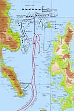 |
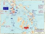
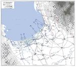
| Map depicting fleet movements during the Battle of Leyte Gulf, 24-25 Oct 1944 | Map depicting fleet movements during the Battle of Surigao Strait, 25 Oct 1944 |
 | 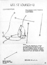 |
| Map depicting fleet movements during the Battle off Samar, 25 Oct 1944 | Sketch excerpted from USS St. Louis’s action report showing paths of nine special attack planes that dived on the ship in Leyte Gulf, Philippines, 27 Nov 1944. |
 | 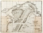 |
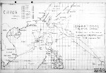
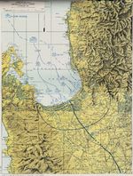
| Map depicting US 6th Army operations at Leyte and Samar, Philippine Islands, 17 Oct-30 Dec 1944 | US Navy 1944 berthing chart for the Northern Anchorage of the Ulithi Lagoon, Caroline Islands |
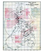 |  |
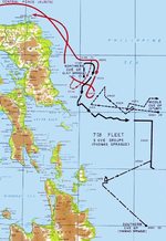
| United States Army map showing all identified Japanese airfields within 300 miles of the Philippine island of Mindoro. This map was prepared as part of the Mindoro invasion plans, 15 Dec 1944. | Task Force 38 operational track for Operation Gratitude into the South China Sea, Dec 30, 1944 through Jan 26, 1945. |
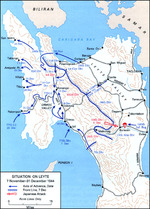 |  |
| US map of the situation on Leyte, Philippine Islands, as of 31 Dec 1944 | Map depicting the campaign in the Philippine Islands, 13 Dec 1944-24 Jan 1945 |
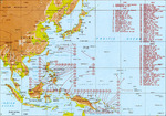 | 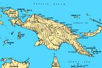 |
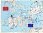
| Map of major Pacific War engagements, 1942-1945 | Map of New Guinea, showing major coastal strategic regions |
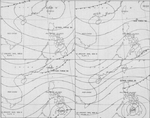 |  |
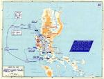
| Four-part weather map of the South China Sea for Jan 7 to 10, 1945. Note daily positions of Task Force 38. | Map of landing beaches in Lingayen Gulf, Luzon, Philippine Islands, 9 Jan 1945 |
 |  |
| United States Army operations map of Lingayen Gulf, Luzon, Philippines showing the Landing beaches for the 9 Jan 1945 landings. | Four-part weather map of the South China Sea for Jan 11 to 14, 1945. Note daily positions of Task Force 38. |
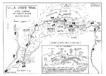 |  |
| Map of the Villa Verde trail used by the US 32nd Infantry Division during the Luzon Campaign, Jan 30 through May 28, 1945 | Map of the American campaign on Luzon, Philippine Islands, 9 Jan-4 Feb 1945 |
 |  |
| Contour map of Iwo Jima, showing Japanese defense installations as observed from ground study during the period of 19 Feb-19 Mar 1945, map 1 of 2 | Contour map of Iwo Jima, showing Japanese defense installations as observed from ground study during the period of 19 Feb-19 Mar 1945, map 2 of 2 |
169 items in this album on 9 pages.
Change View
Desktop ViewSearch WW2DB
News
- » US Women's Army Corps "Six Triple Eight" Awarded with Congressional Gold Medal (30 Apr 2025)
- » Wreck of Soviet Submarine M-49 Found (10 Apr 2025)
- » Japanese Emperor Visited Iwoto (Iwo Jima) (8 Apr 2025)
- » Race, Holocaust, and African-American WW2 Histories Removed from the US Naval Academy Library (7 Apr 2025)
- » US Government Plans to Purge WW2 Information (17 Mar 2025)
- » See all news
Random Photograph
Current Site Statistics
- » 1,167 biographies
- » 337 events
- » 44,615 timeline entries
- » 1,244 ships
- » 350 aircraft models
- » 207 vehicle models
- » 376 weapon models
- » 123 historical documents
- » 261 facilities
- » 470 book reviews
- » 28,517 photos
- » 365 maps
Famous WW2 Quote
"All right, they're on our left, they're on our right, they're in front of us, they're behind us... they can't get away this time."Lt. Gen. Lewis B. "Chesty" Puller, at Guadalcanal