432 items in this album on 22 pages.
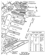 |  |
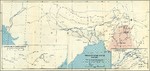
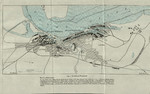
| Dock plan with crane locations at the Norfolk Navy Yard, Portsmouth, Virginia, United States. | Map depicting Allied lines of communications in India, Burma, into southern China, 1942-1943 |
 | 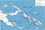 |
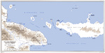
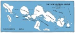
| Map depicting the transportation routes in the China-Burma-India theater, 1942-1943 | Map noting the Solomon Islands situation in 1943 |
 |  |
| Map of the shipbuilding district at the bend of the Geeste River in Bremerhaven, Germany, circa 1940s; note Rickmers, Tecklenborg, Seebeckwerft, and Schiffsbau Gesellschaft Unterweser | United States Army map of the Vitiaz and Dampier Straits between Cape Cretin, New Guinea and Cape Gloucester, New Britain, 1943. |
 | 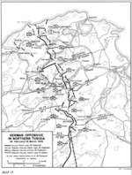 |
| US Pilot’s Strip Chart of “The Slot” in the Solomon chain with ranges indicated from Henderson Field, Guadalcanal. US aircraft flying from Henderson Field were colloquially known as the “Cactus Air Force” after their radio call sign. | Map depicting German follow-up actions in northwestern Tunisia after Battle of Kasserine Pass, 26 Feb-15 Mar 1943 |
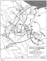 | 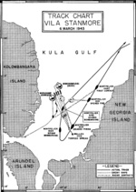 |
| Map depicting the Battle of Medenine in Tunisia, 6 Mar 1943 | Track chart featuring the movements of USS Montpelier during the action in Kula Gulf, Solomon Islands on 6 Mar 1943 where Japanese destroyers Murasame and Minegumo were sunk. |
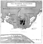 | 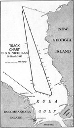 |
| US Navy chart showing the positions of Vila airstrip and Stanmore Plantation on Kolombangara Island next to Blackett Strait, Solomon Islands, 6 Mar 1943. The US Navy subjected this area to many naval bombardments. | Track chart featuring the movements of USS Nicholas during the action of 16 Mar 1943 in Kula Gulf, Solomon Islands. |
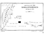 | 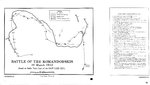 |
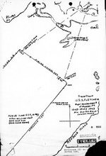
| Map of the Komandorski Islands showing the area of action for 26 Mar 1943, prepared for the United States Navy Office of Naval Intelligence Combat Narrative report. | Track of the Battle of the Komandorski Islands, 26 Mar 1943, prepared for the United States Navy Office of Naval Intelligence Combat Narrative report. |
 | 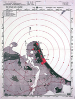 |
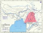
| Map depicting German and Russian maneuvers at the Third Battle of Kharkov | Map of PeenemĂĽnde, Germany drawn by the British, Apr 1943 |
 |  |
| Track chart from the shelling of Munda Point, New Georgia, Solomon Islands by destroyer USS Fletcher, 13 May 1943. | Track chart showing USS Honolulu’s movements during a bombardment of the Vila Plantation in the Kula Gulf, Solomon Islands, 13 May 1943; taken from Honolulu’s action report. |
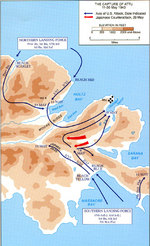 |  |
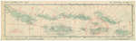
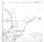
| Map depicting the American operations on Attu Island, Aleutian Islands, US Territory of Alaska, 11-30 May 1945 | United States Marine Corps map of the New Georgia Group in the Solomon Islands, Mar 1943. |
432 items in this album on 22 pages.
Change View
Desktop ViewSearch WW2DB
News
- » WW2DB's 19th Anniversary (29 Dec 2023)
- » Looted Painting "Madonna with Child" Returned to Poland (2 Jun 2023)
- » Wreck of USS Mannert L. Abele Found (29 May 2023)
- » Wreck of Montevideo Maru Found (25 Apr 2023)
- » Accidental Detonation of a WW2-Era Bomb in Great Yarmouth (10 Feb 2023)
- » See all news
Random Photograph
Current Site Statistics
- » 1,150 biographies
- » 337 events
- » 43,556 timeline entries
- » 1,239 ships
- » 349 aircraft models
- » 207 vehicle models
- » 372 weapon models
- » 123 historical documents
- » 259 facilities
- » 468 book reviews
- » 28,413 photos
- » 432 maps
Famous WW2 Quote
"No bastard ever won a war by dying for his country. You win the war by making the other poor dumb bastard die for his country!"George Patton, 31 May 1944