432 items in this album on 22 pages.
 | 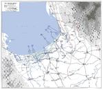 |
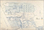
| Hand-drawn map of Air Group 80 of USS Ticonderoga 9 Jan 1945 attack on Heito Airfield, southern Taiwan | Map of landing beaches in Lingayen Gulf, Luzon, Philippine Islands, 9 Jan 1945 |
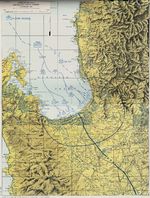 |  |
| United States Army operations map of Lingayen Gulf, Luzon, Philippines showing the Landing beaches for the 9 Jan 1945 landings. | Four-part weather map of the South China Sea for Jan 11 to 14, 1945. Note daily positions of Task Force 38. |
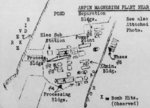 | 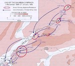 |
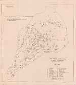
| Hand-drawn post-raid map of Kaneka Soda Company chemical plant (mis-identified as a magnesium plant) by personnel of Air Group 80 aboard USS Ticonderoga, 15 Jan 1945 or later; the facilities were located in Anpin District, Tainan, Taiwan | Map depicting the Salween Offensive, 3 Nov 1944-27 Jan 1945 |
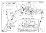 |  |
| Map of the Villa Verde trail used by the US 32nd Infantry Division during the Luzon Campaign, Jan 30 through May 28, 1945 | Map of the American campaign on Luzon, Philippine Islands, 9 Jan-4 Feb 1945 |
 |  |
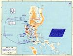
| Map showing the summary of Allied campaigns and Japanese dispositions in the Pacific Ocean as of 1 Feb 1945 | Map depicting the British third campaign in Burma, Jun 1944-Mar 1945 |
 |  |
| Contour map of Iwo Jima, showing Japanese defense installations as observed from ground study during the period of 19 Feb-19 Mar 1945, map 1 of 2 | Contour map of Iwo Jima, showing Japanese defense installations as observed from ground study during the period of 19 Feb-19 Mar 1945, map 2 of 2 |
 | 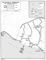 |
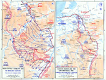
| Map depicting the Allied advance to the Rhine River in West-Central Germany and Belgium, 8 Feb-10 Mar 1945 | United States Army map of the invasion beachhead at Zamboanga, Mindanao, Philippines depicting the progress after the landings of 10 Mar 1945. |
 |  |
| Mar 1945 map showing the general arrangement of the Kaiser Oregon Shipbuilding Corporation yard, Portland, Oregon, United States. | Map of defensive installations on Iwo Jima, Japan, 19 Feb-19 Mar 1945 |
 | 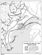 |
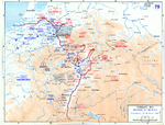
| Map depicting the Allied advance to the Rhine River in West-Central Germany, Eastern France, and the Low Countries, 8 Feb-21 Mar 1945 | United States Army map of the invasion beachhead at Cebu City, Cebu Island, Philippines depicting the progress after the landings of 26 Mar 1945. |
 |  |
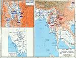
| Map depicting the crossing of the Rhine, 22-28 Mar 1945 | Hand-drawn map of Taiwan-Okinawa region by British Pacific Fleet personnel, circa Apr 1945 |
432 items in this album on 22 pages.
Change View
Desktop ViewSearch WW2DB
News
- » WW2DB's 19th Anniversary (29 Dec 2023)
- » Looted Painting "Madonna with Child" Returned to Poland (2 Jun 2023)
- » Wreck of USS Mannert L. Abele Found (29 May 2023)
- » Wreck of Montevideo Maru Found (25 Apr 2023)
- » Accidental Detonation of a WW2-Era Bomb in Great Yarmouth (10 Feb 2023)
- » See all news
Random Photograph
Current Site Statistics
- » 1,146 biographies
- » 337 events
- » 43,422 timeline entries
- » 1,237 ships
- » 349 aircraft models
- » 207 vehicle models
- » 372 weapon models
- » 123 historical documents
- » 259 facilities
- » 468 book reviews
- » 28,395 photos
- » 432 maps
Famous WW2 Quote
"Never in the field of human conflict was so much owed by so many to so few."Winston Churchill, on the RAF