| Historical Information | ||||||
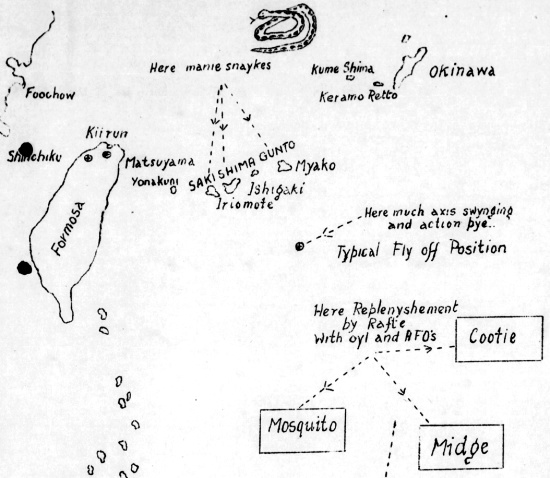
| Caption | Hand-drawn map of Taiwan-Okinawa region by British Pacific Fleet personnel, circa Apr 1945 ww2dbase | |||||
| WW2-Era Location Name | Miyako, Okinawa, Japan | |||||
| Date | Apr 1945 | |||||
| Photographer | Unknown | |||||
| Source Information | ||||||
| Source | ww2dbaseBritish Royal Navy | |||||
| Related Content | ||||||
| More on... |
| |||||
| Licensing Information | ||||||
| Licensing | According to the United Kingdom National Archives, Crown copyright material that has been created prior to 1 Jun 1957 is considered to be in the public domain. Please contact us regarding any inaccuracies with the above information. Thank you. |
|||||
| Metadata | ||||||
| Added By | C. Peter Chen | |||||
| Photo Size | 550 x 478 pixels | |||||
Please consider supporting us on Patreon. Even $1 per month will go a long way! Thank you. Please help us spread the word: Stay updated with WW2DB: |
Change View
Desktop ViewSearch WW2DB

Map
WW2-Era Location Name:Miyako, Okinawa, Japan
Latitude-Longitude:
24.7718, 125.3296
Current Site Statistics
- » 1,182 biographies
- » 337 events
- » 45,131 timeline entries
- » 1,249 ships
- » 350 aircraft models
- » 207 vehicle models
- » 376 weapon models
- » 123 historical documents
- » 261 facilities
- » 471 book reviews
- » 28,435 photos
- » 365 maps
Famous WW2 Quote
"An appeaser is one who feeds a crocodile, hoping it will eat him last."Winston Churchill