432 items in this album on 22 pages.
 | 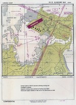 |
| Aviation Approach Chart for Naval Air Station Kahului, Maui, US Territory of Hawaii, dated 1 Jul 1944 | Aviation Approach Chart for Naval Air Station Kaneohe, Oahu, US Territory of Hawaii, dated 1 Jul 1944 |
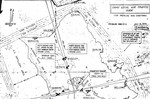 | 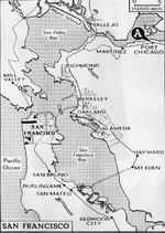 |
| Oahu Air Traffic Plan, Jul 15, 1944. | Map showing Port Chicago’s location within the greater San Francisco Bay, California, United States. |
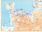 | 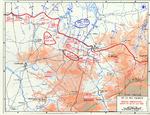 |
| Map depicting the Allied attempt to expand the beachhead at Normandy, France, 1-24 Jul 1944 | Map depicting the situation near Saint-LĂ´, France during the night of 24-25 Jul 1944 |
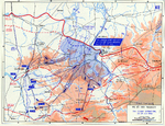 |  |
| Map depicting the situation near Saint-LĂ´, France during Operation Cobra, 25-29 Jul 1944 | Map depicting the Allied breakthrough at Saint-LĂ´, France, 25-31 Jul 1944 |
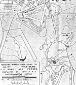 | 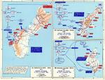 |
| Aug 1944 chart of Wheeler Field, Oahu, Hawaii. This is one of the few charts that also shows the nearby Waieli Gulch airstrip and Kipapa Field, now covered with houses. | Map of the American invasions of Saipan, Tinian, and Guam of the Mariana Islands, 15 Jun-8 Aug 1944 |
 | 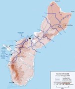 |
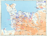
| Map depicting the US 1st Army's breakout in Normandy, France, 24 Jul-4 Aug 1944 | Map of Guam, Mariana Islands and American advances on the island between 21 Jul and 10 Aug 1944 |
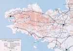 |  |
| Map depicting US Army VII Corps advancing into Brittany, France, 1-12 Aug 1944 | Map depicting the Allied breakout in Normandy, France, 1-13 Aug 1944 |
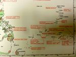 | 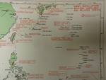 |
| Map showing Japanese positions across the southern Pacific, published in US Pacific Fleet and Pacific Ocean Areas Information Bulletin No. 124-44 of 15 Aug 1944 | Map showing Japanese positions across the western Pacific, published in US Pacific Fleet and Pacific Ocean Areas Information Bulletin No. 124-44 of 15 Aug 1944 |
 |  |
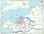
| Map showing Japanese positions at the Palau Islands, published in US Pacific Fleet and Pacific Ocean Areas Information Bulletin No. 124-44 of 15 Aug 1944 | Strategic map of the United States Navy’s actions during the landings in Southern France, 15 Aug 1944. |
 |  |
| Map depicting Operation Bagration, 22 Jun-19 Aug 1944 | Map of Southern France during Operation Dragoon, 15-28 Aug 1944 |
432 items in this album on 22 pages.
Change View
Desktop ViewSearch WW2DB
News
- » WW2DB's 19th Anniversary (29 Dec 2023)
- » Looted Painting "Madonna with Child" Returned to Poland (2 Jun 2023)
- » Wreck of USS Mannert L. Abele Found (29 May 2023)
- » Wreck of Montevideo Maru Found (25 Apr 2023)
- » Accidental Detonation of a WW2-Era Bomb in Great Yarmouth (10 Feb 2023)
- » See all news
Random Photograph
Current Site Statistics
- » 1,150 biographies
- » 337 events
- » 43,556 timeline entries
- » 1,240 ships
- » 349 aircraft models
- » 207 vehicle models
- » 372 weapon models
- » 123 historical documents
- » 259 facilities
- » 468 book reviews
- » 28,414 photos
- » 432 maps
Famous WW2 Quote
"You ask, what is our aim? I can answer in one word. It is victory. Victory at all costs. Victory in spite of all terrors. Victory, however long and hard the road may be, for without victory there is no survival."Winston Churchill