Guilin Airfield
| Type | 77 Air Base | |
| Historical Name of Location | Liangjiang, Guangxi, China | |
| Coordinates | 25.218056000, 110.039167000 |
Contributor: C. Peter Chen
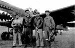
ww2dbaseThe Guilin Airfield (Postal Map romanization: Kweilin) in Guangxi Province in southern China. Between late 1943 and late 1944, it was used by US 23rd Fighter Group "Flying Tigers", flying P-40 Warhawk and P-51 Mustang fighters, and US 8th Reconnaissance Group, flying photographic reconnaissance variant of P-38 Lightning aircraft. Starting in late 1944, it was taken over by the Chinese-American Composite Wing, flying B-25 Mitchell bombers and P-51 Mustang fighters. The airfield was closed in Sep or Oct 1945. Today it is being used as the civilian Guilin Liangjiang International Airport.
ww2dbaseSource: Wikipedia
Last Major Update: Feb 2014
Guilin Airfield Interactive Map
Photographs
 |  |
Please consider supporting us on Patreon. Even $1 per month will go a long way! Thank you. Please help us spread the word: Stay updated with WW2DB: |

Liangjiang, Guangxi, China
Latitude-Longitude:
25.2181, 110.0392
| |
- » 1,181 biographies
- » 337 events
- » 45,111 timeline entries
- » 1,247 ships
- » 350 aircraft models
- » 207 vehicle models
- » 376 weapon models
- » 123 historical documents
- » 261 facilities
- » 470 book reviews
- » 28,469 photos
- » 365 maps
James Forrestal, Secretary of the Navy, 23 Feb 1945