365 items in this album on 19 pages.
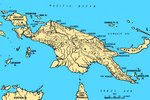 | 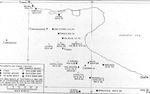 |
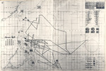
| Map of New Guinea, showing major coastal strategic regions of the 1940s | Map of the Foggia Aerodrome complex showing the USAAF 15th Air Force units assigned to each airstrip |
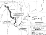 | 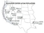 |
| Map showing the fuel pipelines built along the Ledo (Stilwell) Road from Assam, India through Burma (now Myanmar) to Kunming, China, 1945. | Map showing the locations of all ten Relocation Centers for deported Japanese-Americans with figures showing each camp’s maximum population during the war. |
 | 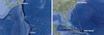 |
| Map showing wartime track of USS Intrepid | Maps comparing the routes between Tinian and Tokyo and between Borinquen Field, Puerto Rico and Baltimore, Maryland, United States. |
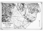 | 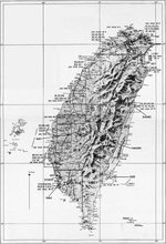 |
| United States Army adaptation of a Japanese map of the Taitō District (now Taitung) on the east coast of Taiwan. | United States Army Air Force map of Taiwan. |
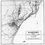 |  |
| United States Army map of the Karenko District (now Hualien) on the east coast of Taiwan. | Post-mission map of the Air Group 80 of USS Ticonderoga 3 Jan 1945 attack on Taichu Airfield, central Taiwan |
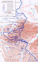 |  |
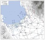
| Map showing American troops reclaiming territory lost during early days of the Battle of the Bulge, 26 Dec 1944-5 Jan 1945 | Four-part weather map of the South China Sea for Jan 7 to 10, 1945. Note daily positions of Task Force 38. |
 |  |
| Hand-drawn map of Air Group 80 of USS Ticonderoga 9 Jan 1945 attack on Heito Airfield, southern Taiwan | Map of landing beaches in Lingayen Gulf, Luzon, Philippine Islands, 9 Jan 1945 |
 |  |
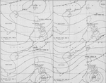
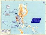
| United States Army operations map of Lingayen Gulf, Luzon, Philippines showing the Landing beaches for the 9 Jan 1945 landings. | Four-part weather map of the South China Sea for Jan 11 to 14, 1945. Note daily positions of Task Force 38. |
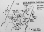 |  |
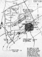
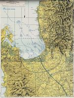
| Hand-drawn post-raid map of Kaneka Soda Company chemical plant (mis-identified as a magnesium plant) by personnel of Air Group 80 aboard USS Ticonderoga, 15 Jan 1945 or later; the facilities were located in Anpin District, Tainan, Taiwan | Map depicting the Salween Offensive in southern China and northern Burma, 3 Nov 1944-27 Jan 1945 |
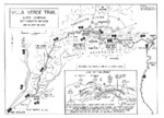 |  |
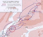
| Map of the Villa Verde trail used by the US 32nd Infantry Division during the Luzon Campaign, Jan 30 through May 28, 1945 | Map of the American campaign on Luzon, Philippine Islands, 9 Jan-4 Feb 1945 |
365 items in this album on 19 pages.
Change View
Desktop ViewSearch WW2DB

News
- » The Emperor of Japan Planned to Honor WW2-era Japanese POWs in Mongolia (4 Jul 2025)
- » US State Lawmaker John Winter Caught Using Racial Slur "Jap" and Apologized (11 Jun 2025)
- » Köln/Cologne Evacuated After Discovery of WW2 Bombs (4 Jun 2025)
- » Race, Holocaust, and African-American WW2 Histories Removed from the US Naval Academy Library (7 Apr 2025)
- » US Government Plans to Purge WW2 Information (17 Mar 2025)
- » See all news
Current Site Statistics
- » 1,177 biographies
- » 337 events
- » 44,938 timeline entries
- » 1,245 ships
- » 350 aircraft models
- » 207 vehicle models
- » 376 weapon models
- » 123 historical documents
- » 261 facilities
- » 470 book reviews
- » 28,478 photos
- » 365 maps
Famous WW2 Quote
"With Germany arming at breakneck speed, England lost in a pacifist dream, France corrupt and torn by dissension, America remote and indifferent... do you not tremble for your children?"Winston Churchill, 1935