| Historical Information | ||||||
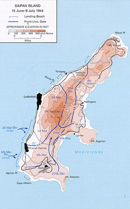
| Caption | Map of the Battle of Saipan Jun 15 through July 9, 1944 ww2dbase | |||||
| WW2-Era Location Name | Saipan, Mariana Islands | |||||
| Date | 15 Jun 1944 | |||||
| Photographer | Unknown | |||||
| Source Information | ||||||
| Source | ww2dbaseUnited States National Archives | |||||
| Related Content | ||||||
| More on... |
| |||||
| Photos on Same Day | 15 Jun 1944 | |||||
| Colorized By WW2DB |
Colorized with Adobe Photoshop |
|||||
| Licensing Information | ||||||
| Licensing | Public Domain. According to the US National Archives, as of 21 Jul 2010: Please contact us regarding any inaccuracies with the above information. Thank you. |
|||||
| Metadata | ||||||
| Added By | David Stubblebine | |||||
| Photo Size | 450 x 720 pixels | |||||
Please consider supporting us on Patreon. Even $1 per month will go a long way! Thank you. Please help us spread the word: Stay updated with WW2DB: |
Visitor Submitted Comments
2. Larry says:
23 Jul 2019 12:42:04 PM
I have battle map of Saipan from fathers collection. He got it on saipan. used it to call artillery on *** . it has every *** position on it . say's secret on it. only saw one other. would like to know more about it and value..
23 Jul 2019 12:42:04 PM
I have battle map of Saipan from fathers collection. He got it on saipan. used it to call artillery on *** . it has every *** position on it . say's secret on it. only saw one other. would like to know more about it and value..
3. Anonymous says:
18 May 2021 12:42:42 PM
This may have been covered so forgive me for asking, is there an easy way to print any of these map? I have found having a relevant map while reading helps to “see” the action.
Thanks in advance for any suggestions
18 May 2021 12:42:42 PM
This may have been covered so forgive me for asking, is there an easy way to print any of these map? I have found having a relevant map while reading helps to “see” the action.
Thanks in advance for any suggestions
All visitor submitted comments are opinions of those making the submissions and do not reflect views of WW2DB.
Change View
Desktop ViewSearch WW2DB

Map
WW2-Era Location Name:Saipan, Mariana Islands
Latitude-Longitude:
15.1833, 145.7500
Random Photograph
Current Site Statistics
- » 1,182 biographies
- » 337 events
- » 45,119 timeline entries
- » 1,249 ships
- » 350 aircraft models
- » 207 vehicle models
- » 376 weapon models
- » 123 historical documents
- » 261 facilities
- » 470 book reviews
- » 28,415 photos
- » 365 maps
Famous WW2 Quote
"You ask, what is our aim? I can answer in one word. It is victory. Victory at all costs. Victory in spite of all terrors. Victory, however long and hard the road may be, for without victory there is no survival."Winston Churchill
23 Feb 2017 05:38:37 AM
This unfortunate map has assumed undue prominence in conveying the progress of the Battle of Saipan. In fact, it is taken from the short 34 page brochure entitled "Western Pacific" published 50 years after the Battle of Saipan by the US Army Center for Military History (CMH). As such, this map is a misleading representation of the progress of the Battle of Saipan.
For example, the US Army's 27th Division appears to materialize "out of nowhere" in the Southeastern corner of Saipan, driving up to capture territory along a central corridor of Saipan, all the way to the Northeastern coast. This is completely incorrect:
[URLs below from USMC maps produced originally in 1950, note use "http" not "https"]:
ibiblio[dot]org/hyperwar/USMC/USMC-M-Saipan/maps/USMC-M-Saipan-5.jpg
ibiblio[dot]org/hyperwar/USMC/USMC-M-Saipan/maps/USMC-M-Saipan-8.jpg
ibiblio[dot]org/hyperwar/USMC/USMC-M-Saipan/maps/USMC-M-Saipan-10.jpg
ibiblio[dot]org/hyperwar/USMC/USMC-M-Saipan/maps/USMC-M-Saipan-11.jpg
ibiblio[dot]org/hyperwar/USMC/USMC-M-Saipan/maps/USMC-M-Saipan-13.jpg
ibiblio[dot]org/hyperwar/USMC/USMC-M-Saipan/maps/USMC-M-Saipan-14.jpg
Initial landings were on the western coast of Saipan by the USMC 2nd Division (northern beaches) and USMC 4th Division (southern beaches) on June 15, 1944, establishing the beachhead and subsequently driving inland. Elements of the US Army 27th Division followed, landing into captured territory on June 16th and June 17th (D+1, D+2), joining the front lines on June 17th in the southernmost sector.
The 4th Marine Division cut the island of Saipan in half by a drive to the eastern coast on June 18th, turned northward, and continued driving with the USMC 2nd Division on their left flank until reaching within a few miles of Mt. Tapotchau on June 22nd (D+7). On their left flank, the 2nd Marine Division would later capture Mt. Tapotchau and the town of Garapan.
[URLs below from USMC maps produced originally in 1945, note use "http" not "https"]:
ibiblio[dot]org/hyperwar/USMC/USMC-C-Saipan/maps/USMC-C-Saipan-2.jpg
ibiblio[dot]org/hyperwar/USMC/USMC-C-Saipan/maps/USMC-C-Saipan-3.jpg
Military leadership decided that due to the broadening of the main northward front where the Kagman Peninsula jutted out, a three Division front would be required. The 27th Division had fought to capture Aslito Alirfield and Nafutan Point up to this timepoint in the battle (see map 16 below for problems). Elements of the 27th Division traversed northward through captured territory and were inserted into the center of the main front lines (extending east-to-west) on June 23rd (D+8). This is where the 27th Division ran into difficulties, lagging behind troops on their flanks, a situation that remained unresolved until approximately July 2nd (D+17).
[URLs below from USMC maps produced originally in 1950, note use "http" not "https"]:
ibiblio[dot]org/hyperwar/USMC/USMC-M-Saipan/maps/USMC-M-Saipan-17.jpg
ibiblio[dot]org/hyperwar/USMC/USMC-M-Saipan/maps/USMC-M-Saipan-16.jpg
ibiblio[dot]org/hyperwar/USMC/USMC-M-Saipan/maps/USMC-M-Saipan-18.jpg
ibiblio[dot]org/hyperwar/USMC/USMC-M-Saipan/maps/USMC-M-Saipan-19.jpg
ibiblio[dot]org/hyperwar/USMC/USMC-M-Saipan/maps/USMC-M-Saipan-20.jpg
Thus the US Army 27th Division captured territory in Southern/Southeastern Saipan, and again captured a corridor east of Mt. Taotchau to the Northeastern coast near Flores Point, but did not capture territory in between. Also, while the US Army map would suggest that US forces drove northward in a coordinated effort, in fact, US Army 27th Division forces appeared to lag until the last 3 days of the northern drive, June 2nd-4th (see map 20 above).
The best map of division-level progress of the battle can be found on pg 21 of the book "The 4th Marine Division in World War II" initially published in 1945, detailing the 4th Marine Division's capture of territory from Blue/Yellow beaches all the way up to Marpi Point, the largest area (by far) captured by a Division during the Battle of Saipan:
ia902602[dot]us[dot]archive[dot]org/6/items/The4thMarineDivisionInWorldWarII/The4thMarineDivisionInWorldWarII.pdf