432 items in this album on 22 pages.
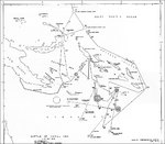 | 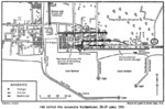 |
| Map of Battle of Coral Sea, part of Captain Mineo Yamaoka's interrogation, 19 Oct 1945 | Map of the Battle for the Kalamata waterfront, Kalamata, Greece, Apr 28, 1941. |
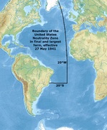 | 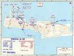 |
| Map showing the final boundaries of the United States Atlantic Neutrality Zone that became effective 27 May 1941. | Map depicting the German assault on Crete, Greece, 20-31 May 1941 |
 | 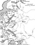 |
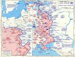
| Map of Operation Barbarossa, 22 Jun to 25 Aug 1941 | Battle plans for Barbarossa |
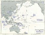 | 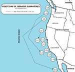 |
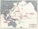
| Map showing the positions of major Allied forces at the start of the Pacific War, Dec 1941 | Positions of Japanese I-class submarines during Dec 1941 operations off the United States’ Pacific coast. |
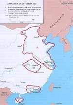 |  |
| Map depicting Japanese plans for occupying China immediately before launching the third attack on Changsha, China, 3 Dec 1941 | Map depicting the German advance on Moscow, Russia, 26 Aug-5 Dec 1941 |
 | 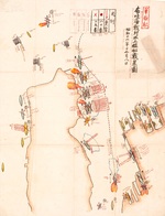 |
| Plot of USS Nevada's movements during the Pearl Harbor attack, Dec 7 1941. | Japanese map showing their assessment of the damage done to the United States fleet at Pearl Harbor, Hawaii on 7 Dec 1941 |
 |  |
| Map noting American dispositions at Luzon, Philippine Islands on 8 Dec 1941 | Pearl Harbor chart found in Japanese submarine Ha-19 |
 |  |
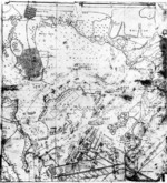
| Japanese Pearl Harbor attack fleet track chart, 26 Nov-23 Dec 1941 | Map showing Japanese offensives in Dec 1941 |
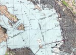 |  |
| Excerpt from the 1942 United States Army Corps of Engineers map of San Francisco Bay showing the Kaiser Richmond Shipyards at Potrero Point and the Tiburon Naval Net Depot across the bay north of Bluff Point. | Map noting Japanese objectives in the opening stages of the Pacific War in late 1941 to early 1942 |
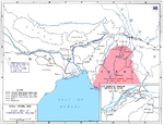 | 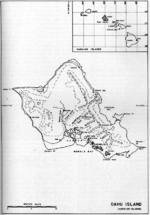 |
| Map of eastern India and northern Burma showing Japanese occupation and Allied supply routes in 1942. Note Burma Road, The Hump route, and the track of the future Ledo Road that opened in 1945. | Map of Oahu, US Territory of Hawaii, 1940s |
432 items in this album on 22 pages.
Change View
Desktop ViewSearch WW2DB
News
- » WW2DB's 19th Anniversary (29 Dec 2023)
- » Looted Painting "Madonna with Child" Returned to Poland (2 Jun 2023)
- » Wreck of USS Mannert L. Abele Found (29 May 2023)
- » Wreck of Montevideo Maru Found (25 Apr 2023)
- » Accidental Detonation of a WW2-Era Bomb in Great Yarmouth (10 Feb 2023)
- » See all news
Random Photograph
Current Site Statistics
- » 1,146 biographies
- » 336 events
- » 43,422 timeline entries
- » 1,237 ships
- » 349 aircraft models
- » 207 vehicle models
- » 372 weapon models
- » 123 historical documents
- » 259 facilities
- » 468 book reviews
- » 28,395 photos
- » 432 maps
Famous WW2 Quote
"I have returned. By the grace of Almighty God, our forces stand again on Philippine soil."General Douglas MacArthur at Leyte, 17 Oct 1944