77 items in this album on 4 pages.
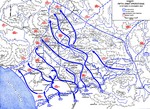 |  |
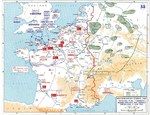
| Map showing US 5th Army advances in Italy, 12 Oct-15 Nov 1943 | Map of Anzio-Cassino area in Italy, 17 Jan-19 Feb 1944 |
 | 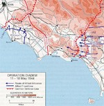 |
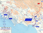
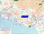
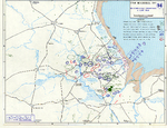
| Map of Allied force dispositions at Anzio, Italy, 1 Feb 1944 | Map of the Allied Operation Diadem plan for the Anzio, Italy area, May 1944 |
 |  |
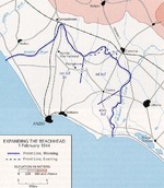
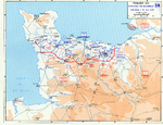
| Map of the Allied breakout from the Anzio, Italy beachhead and advance from the Gustav Line, May 1944 | Map of Allied advance toward Rome, Italy, 31 May-4 Jun 1944 |
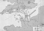 | 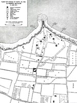 |
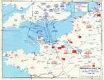
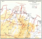
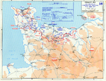
| Map of Normandy assault routes | 1944 United States Army map of the Army Rangers’ attack plan for Pointe du Hoc on the Normandy beaches set for 6 Jun 1944. Note the misspelling of Pointe du Hoc. |
 |  |
| Map depicting Allied bomber offensive plans in the Normandy, France region and German dispositions, 6 Jun 1944 | Map depicting the Utah beachhead, Normandy, France, 6 Jun 1944 |
 |  |
| Map noting Allied and German dispositions in southern England, United Kingdom and Normandy, France on 6 Jun 1944 | Map noting situation at Normandy, France at 2400 hours on 6 Jun 1944; note title text with deceptive American unit FUSAG |
 | 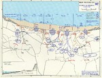 |
| Map of Juno Beach Normandy, France showing 3rd Canadian Infantry Division D-Day landing objectives and front line as of midnight 6 Jun 1944. | Map of the Omaha beachhead, Normandy, France, showing movements of the US Army V Corps, 6 Jun 1944 |
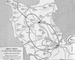 | 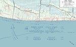 |
| Map showing German dispositions on Cotentin Peninsula in France on 6 Jun 1944 | US Army map of the landing beaches at Utah Beach, Normandy, France, 6 Jun 1944. Note that the planned landing beaches are about 250 yards away from actual landing beaches. |
 | 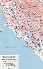 |
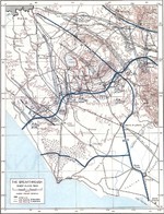
| Map depicting Allied operations in the Normandy, France area, 13-30 Jun 1944 | Map showing Allied advance from Rome toward the Arno River, Italy, 5 Jun-5 Aug 1944 |
 | 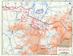 |
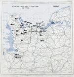
| Map depicting the Allied attempt to expand the beachhead at Normandy, France, 1-24 Jul 1944 | Map depicting the situation near Saint-LĂ´, France during the night of 24-25 Jul 1944 |
77 items in this album on 4 pages.
Change View
Desktop ViewSearch WW2DB
News
- » WW2DB's 19th Anniversary (29 Dec 2023)
- » Looted Painting "Madonna with Child" Returned to Poland (2 Jun 2023)
- » Wreck of USS Mannert L. Abele Found (29 May 2023)
- » Wreck of Montevideo Maru Found (25 Apr 2023)
- » Accidental Detonation of a WW2-Era Bomb in Great Yarmouth (10 Feb 2023)
- » See all news
Random Photograph
Current Site Statistics
- » 1,146 biographies
- » 336 events
- » 43,422 timeline entries
- » 1,237 ships
- » 349 aircraft models
- » 207 vehicle models
- » 372 weapon models
- » 123 historical documents
- » 259 facilities
- » 468 book reviews
- » 28,395 photos
- » 432 maps
Famous WW2 Quote
"The raising of that flag on Suribachi means a Marine Corps for the next 500 years."James Forrestal, Secretary of the Navy, 23 Feb 1945