×
Home Intro People Events Equipment Places Maps Books Photos Videos Other Reference FAQ About
     

World War II Database

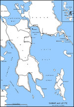
Map of Leyte Gulf, Philippine IslandsMap of Luzon, Philippines from Lingayen Gulf to Manila Bay
Map of the Philippine IslandsMap of the Leyte landing beaches, 20 Oct 1944
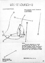
Sketch excerpted from USS St. Louis’s action report showing paths of nine special attack planes that dived on the ship in Leyte Gulf, Philippines, 27 Nov 1944.United States Army map showing all identified Japanese airfields within 300 miles of the Philippine island of Mindoro. This map was prepared as part of the Mindoro invasion plans, 15 Dec 1944.
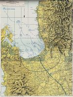
Map of landing beaches in Lingayen Gulf, Luzon, Philippine Islands, 9 Jan 1945United States Army operations map of Lingayen Gulf, Luzon, Philippines showing the Landing beaches for the 9 Jan 1945 landings.
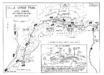
Map of the Villa Verde trail used by the US 32nd Infantry Division during the Luzon Campaign, Jan 30 through May 28, 1945United States Army map of the invasion beachhead at Zamboanga, Mindanao, Philippines depicting the progress after the landings of 10 Mar 1945.
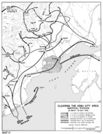
United States Army map of the invasion beachhead at Cebu City, Cebu Island, Philippines depicting the progress after the landings of 26 Mar 1945.


Change View
Desktop View

Search WW2DB
Famous WW2 Quote
"All right, they're on our left, they're on our right, they're in front of us, they're behind us... they can't get away this time."

Lt. Gen. Lewis B. "Chesty" Puller, at Guadalcanal

Support Us

Please consider supporting us on Patreon. Even $1 a month will go a long way. Thank you!

Or, please support us by purchasing some WW2DB merchandise at TeeSpring, Thank you!