 |  |
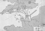
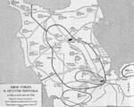
| Map of Normandy assault routes | 1944 United States Army map of the Army Rangers’ attack plan for Pointe du Hoc on the Normandy beaches set for 6 Jun 1944. Note the misspelling of Pointe du Hoc. |
 |  |
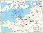
| Map depicting Allied bomber offensive plans in the Normandy, France region and German dispositions, 6 Jun 1944 | Map depicting the Utah beachhead, Normandy, France, 6 Jun 1944 |
 | 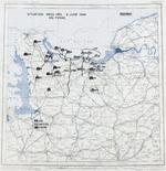 |
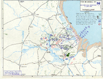
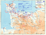
| Map noting Allied and German dispositions in southern England, United Kingdom and Normandy, France on 6 Jun 1944 | Map noting situation at Normandy, France at 2400 hours on 6 Jun 1944; note title text with deceptive American unit FUSAG |
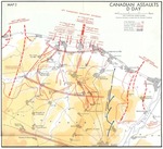 |  |
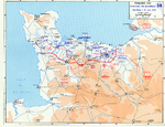
| Map of Juno Beach Normandy, France showing 3rd Canadian Infantry Division D-Day landing objectives and front line as of midnight 6 Jun 1944. | Map of the Omaha beachhead, Normandy, France, showing movements of the US Army V Corps, 6 Jun 1944 |
 | 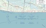 |
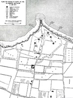
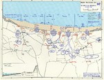
| Map showing German dispositions on Cotentin Peninsula in France on 6 Jun 1944 | US Army map of the landing beaches at Utah Beach, Normandy, France, 6 Jun 1944. Note that the planned landing beaches are about 250 yards away from actual landing beaches. |
 |  |
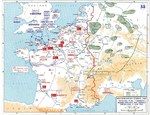
| Map depicting Allied operations in the Normandy, France area, 13-30 Jun 1944 | Map depicting the Allied attempt to expand the beachhead at Normandy, France, 1-24 Jul 1944 |
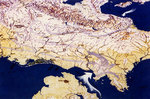 | |
| Graphic chart of Allied advance in France, from Fiscal Years 1944-1945 Biennial Report of Army Chief from Staff General George Marshall to the US Secretary of War, Aug 1945 |

Change View
Desktop ViewSearch WW2DB
News
- » WW2DB's 19th Anniversary (29 Dec 2023)
- » Looted Painting "Madonna with Child" Returned to Poland (2 Jun 2023)
- » Wreck of USS Mannert L. Abele Found (29 May 2023)
- » Wreck of Montevideo Maru Found (25 Apr 2023)
- » Accidental Detonation of a WW2-Era Bomb in Great Yarmouth (10 Feb 2023)
- » See all news
Random Photograph
Current Site Statistics
- » 1,146 biographies
- » 336 events
- » 43,422 timeline entries
- » 1,237 ships
- » 349 aircraft models
- » 207 vehicle models
- » 372 weapon models
- » 123 historical documents
- » 259 facilities
- » 468 book reviews
- » 28,395 photos
- » 432 maps
Famous WW2 Quote
"All right, they're on our left, they're on our right, they're in front of us, they're behind us... they can't get away this time."Lt. Gen. Lewis B. "Chesty" Puller, at Guadalcanal