 |  |
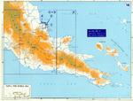
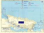
| Map of New Guinea, 1942 | Map showing the extent of Japanese advance in 1942 |
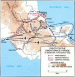 |  |
| Map depicting Japanese attack and withdraw over the Owen Stanley Range, New Guinea, 18 Sep-15 Nov 1942 | Maps of several New Guinea Campaign engagements, mid- to late-1942 |
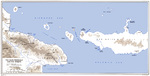 |  |
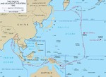
| United States Army map of the Vitiaz and Dampier Straits between Cape Cretin, New Guinea and Cape Gloucester, New Britain, 1943. | Map depicting Operation Cartwheel, 30 Jun 1943 to early 1944 |
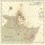 |  |
| Aviation navigational Approach Map to designed guide strike aircraft to Lakunai Aerodrome at Rabaul, New Britain, Bismarck Islands. Map dated Aug 7, 1943. Note other airfields marked on the map. | Map noting engagements in the Solomon Islands and New Guinea, late 1943 to early 1944 |
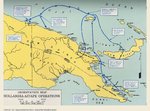 |  |
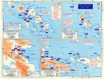
| Map of eastern New Guinea showing Allied troops movements relating to the Hollandia-Aitape landings, Apr 1944. | Map depicting the invasion of Hollandia, New Guinea, 22-26 Apr 1944 |
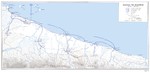 |  |
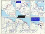
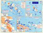
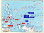
| United States Army map of the invasion beachhead at Aitape, New Guinea depicting the progress after the landings of 23 Apr 1944. | Map depicting Operation Cartwheel and the invasion of Gilbert and Marshall Islands, 30 Jun 1943-26 Apr 1944 |
 | 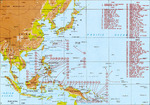 |
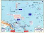
| Map detailing Allied advances in New Guinea and the Mariana Islands, 22 Apr-24 Jul 1944 | Map of major Pacific War engagements, 1942-1945 |
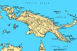 | |
| Map of New Guinea, showing major coastal strategic regions |

Change View
Desktop ViewSearch WW2DB
News
- » WW2DB's 19th Anniversary (29 Dec 2023)
- » Looted Painting "Madonna with Child" Returned to Poland (2 Jun 2023)
- » Wreck of USS Mannert L. Abele Found (29 May 2023)
- » Wreck of Montevideo Maru Found (25 Apr 2023)
- » Accidental Detonation of a WW2-Era Bomb in Great Yarmouth (10 Feb 2023)
- » See all news
Current Site Statistics
- » 1,146 biographies
- » 336 events
- » 43,422 timeline entries
- » 1,237 ships
- » 349 aircraft models
- » 207 vehicle models
- » 372 weapon models
- » 123 historical documents
- » 259 facilities
- » 468 book reviews
- » 28,395 photos
- » 432 maps
Famous WW2 Quote
"We no longer demand anything, we want war."Joachim von Ribbentrop, German Foreign Minister, Aug 1939