22 items in this album on 2 pages.
 |  |
| Track of the cruiser night action of 9 Aug 1942 off Savo Island, Solomon Islands where three United States cruisers and one Australian cruiser were lost. Track is taken from the USS Astoria damage report. | USMC Map 104 showing the northern coast of Guadalcanal in the Lunga area |
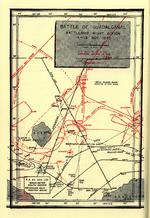 | 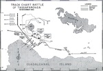 |
| Map depicting Japanese and US Naval movements during the Second Naval Battle of Guadalcanal the night of Nov 14, 1942. | United States Navy Track Chart Battle of Tassafaronga, 30 Nov 1942. Chart created in 1946. |
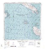 | 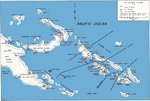 |
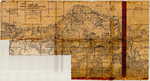
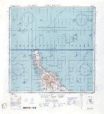
| 1943 United States Army map of western Guadalcanal and the Russel Islands in the Solomon chain. | Map noting the Solomon Islands situation in 1943 |
 |  |
| US Pilot’s Strip Chart of “The Slot” in the Solomon chain with ranges indicated from Henderson Field, Guadalcanal. US aircraft flying from Henderson Field were colloquially known as the “Cactus Air Force” after their radio call sign. | Track chart featuring the movements of USS Montpelier during the action in Kula Gulf, Solomon Islands on 6 Mar 1943 where Japanese destroyers Murasame and Minegumo were sunk. |
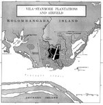 | 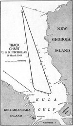 |
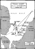
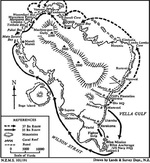
| US Navy chart showing the positions of Vila airstrip and Stanmore Plantation on Kolombangara Island next to Blackett Strait, Solomon Islands, 6 Mar 1943. The US Navy subjected this area to many naval bombardments. | Track chart featuring the movements of USS Nicholas during the action of 16 Mar 1943 in Kula Gulf, Solomon Islands. |
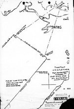 |  |
| Track chart from the shelling of Munda Point, New Georgia, Solomon Islands by destroyer USS Fletcher, 13 May 1943. | Track chart showing USS Honolulu’s movements during a bombardment of the Vila Plantation in the Kula Gulf, Solomon Islands, 13 May 1943; taken from Honolulu’s action report. |
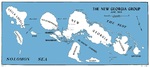 |  |
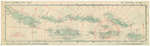
| United States Marine Corps map of the New Georgia Group in the Solomon Islands, Mar 1943. | Map of Vella Lavella in the Solomon Islands created by the New Zealand military depicting the troop movements during the island’s capture, Aug 1943. |
 | 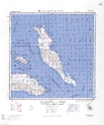 |
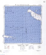
| 1944 United States Army map of Choiseul Island, the northernmost of the Solomon Islands. | 1944 United States Army map of Malaita Island and the eastern end of Guadalcanal in the Solomon Islands. |
 |  |
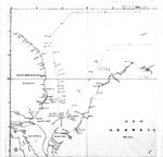
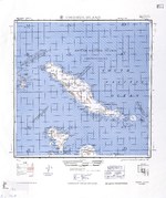
| 1944 United States Army map of New Georgia and Rendova Islands with a portion of the Solomon Sea in the Solomon Islands. | 1944 United States Army map of northern Bougainville and Buka Island in the Bismarck Archipelago. |
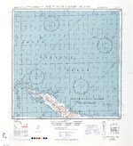 |  |
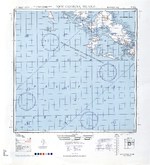
| 1944 United States Army map of northern Santa Isabel Island in the Solomon Islands. | 1944 United States Army map of San Cristobal and Rennell Islands with a portion of the Coral Sea in the Solomon Islands. |
22 items in this album on 2 pages.
Change View
Desktop ViewSearch WW2DB
News
- » WW2DB's 19th Anniversary (29 Dec 2023)
- » Looted Painting "Madonna with Child" Returned to Poland (2 Jun 2023)
- » Wreck of USS Mannert L. Abele Found (29 May 2023)
- » Wreck of Montevideo Maru Found (25 Apr 2023)
- » Accidental Detonation of a WW2-Era Bomb in Great Yarmouth (10 Feb 2023)
- » See all news
Current Site Statistics
- » 1,146 biographies
- » 336 events
- » 43,422 timeline entries
- » 1,237 ships
- » 349 aircraft models
- » 207 vehicle models
- » 372 weapon models
- » 123 historical documents
- » 259 facilities
- » 468 book reviews
- » 28,395 photos
- » 432 maps
Famous WW2 Quote
"Since peace is now beyond hope, we can but fight to the end."Chiang Kaishek, 31 Jul 1937