Kaneohe Naval Air Station
| Type | 70 Air Base | |
| Historical Name of Location | Kaneohe, Oahu, Hawaii | |
| Coordinates | 21.443611000, -157.748889000 |
Contributor: C. Peter Chen
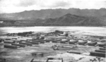
ww2dbasePrior to 1939, the tip of the Mokapu Peninsula between Kaneohe Bay and Kailua Bay in Oahu, US Territory of Hawaii hosted Fort Hase, a US Army base. In 1939, the US Navy acquired 464 acres, or 1.88 square kilometers, of land on the peninsula to establish Naval Air Station Kaneohe for the operation of PBY Catalina seaplanes. The seaplane base was attacked by the Japanese during the Pearl Harbor raid in Dec 1941 (in fact, Kaneohe was attacked several minutes prior to Pearl Harbor itself), destroying 27 of the 36 PBY Catalina aircraft stationed there and killing 18. During the war, Naval Air Station Kaneohe was a training center for aviation, naval gunnery, turret operations, celestial navigation, sonar, and other subjects. Fort Hase was effectively abandoned by the US Army shortly after the war, and Naval Air Station Kaneohe followed suit in 1949. In 1952, US Marine Corps established Marine Corps Air Station Kaneohe Bay on the peninsula, taking over the territory formerly operated by US Army and US Navy. In 1994, it was consolidated, along with other area bases, into Marine Corps Base Hawaii.
ww2dbaseSource: Wikipedia
Last Major Update: Jun 2014
Kaneohe Naval Air Station Interactive Map
Photographs
 | 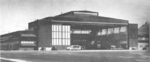 |
Maps
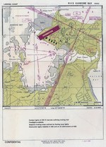 |
Kaneohe Naval Air Station Timeline
| 15 Jan 1952 | Marine Corps Air Station Kaneohe Bay was established on the former site of US Army's Fort Hase and US Navy's Naval Air Station Kaneohe in the US Territory of Hawaii. |
| 28 May 1987 | Kaneohe Naval Air Station was added to the US National Register of Historic Places. |
Did you enjoy this article or find this article helpful? If so, please consider supporting us on Patreon. Even $1 per month will go a long way! Thank you. Share this article with your friends: Stay updated with WW2DB: |
| WW2-Era Place Name | Kaneohe, Oahu, Hawaii |
| Lat/Long | 21.4436, -157.7489 |
- » 1,146 biographies
- » 336 events
- » 43,422 timeline entries
- » 1,237 ships
- » 349 aircraft models
- » 207 vehicle models
- » 372 weapon models
- » 123 historical documents
- » 259 facilities
- » 468 book reviews
- » 28,395 photos
- » 432 maps
Winston Churchill